
Anak Krakatau now covers more land than before its 2018 collapse
The Indonesian volcano has rebuilt the area lost in its 2018 collapse. After September’s eruption, satellite imagery measured 341.5 hectares above sea level and revealed two formations that are still under investigation.
Leitura autorizada · 3 crédito(s) restante(s)
Anak Krakatau is an island volcano in Indonesia’s Sunda Strait, between Java and Sumatra. It began forming underwater in 1927, inside the caldera left by the ancestral Krakatau eruption of 1883, and emerged above the sea in 1929. In December 2018, the collapse of its southwestern flank sent material into the water, triggered the Sunda Strait tsunami and reduced the volcano’s area from about 300 to 246.18 hectares.
From September 4 to 6, 2026, the volcano went through a continuous eruptive phase lasting about 25 hours. Lava fountains rose above the crater, flows advanced northwest, west and southwest, and the ash column reached 15.2 kilometers above sea level. Eight airports temporarily closed, and nearly 3,000 flights were rerouted, delayed or canceled. The most intense phase ended; on September 21, as activity declined, Indonesia lowered the alert from Level III to Level II. A 2-kilometer exclusion zone remains around the center of activity.
Against that background, Indonesia’s Center for Volcanology and Geological Hazard Mitigation, or PVMBG, compared recent Sentinel satellite images. The analysis measured 341.5 hectares of exposed land—the part of the volcanic terrain that remains above sea level and whose outline can be mapped by satellite. The area already exceeds the roughly 300 hectares recorded before the 2018 collapse. Specialists also located two small formations near the coast.
Within the full outline, 32.8 hectares were covered by deposits from the September eruption. That is 328,000 square meters: about 46 football pitches measuring 105 by 68 meters, or a square roughly 573 meters on each side. Some lava and fragments may have covered land that already existed. The 32.8 hectares therefore measure the coverage of recent deposits, whereas the 341.5 hectares measure the entire surface above the sea.
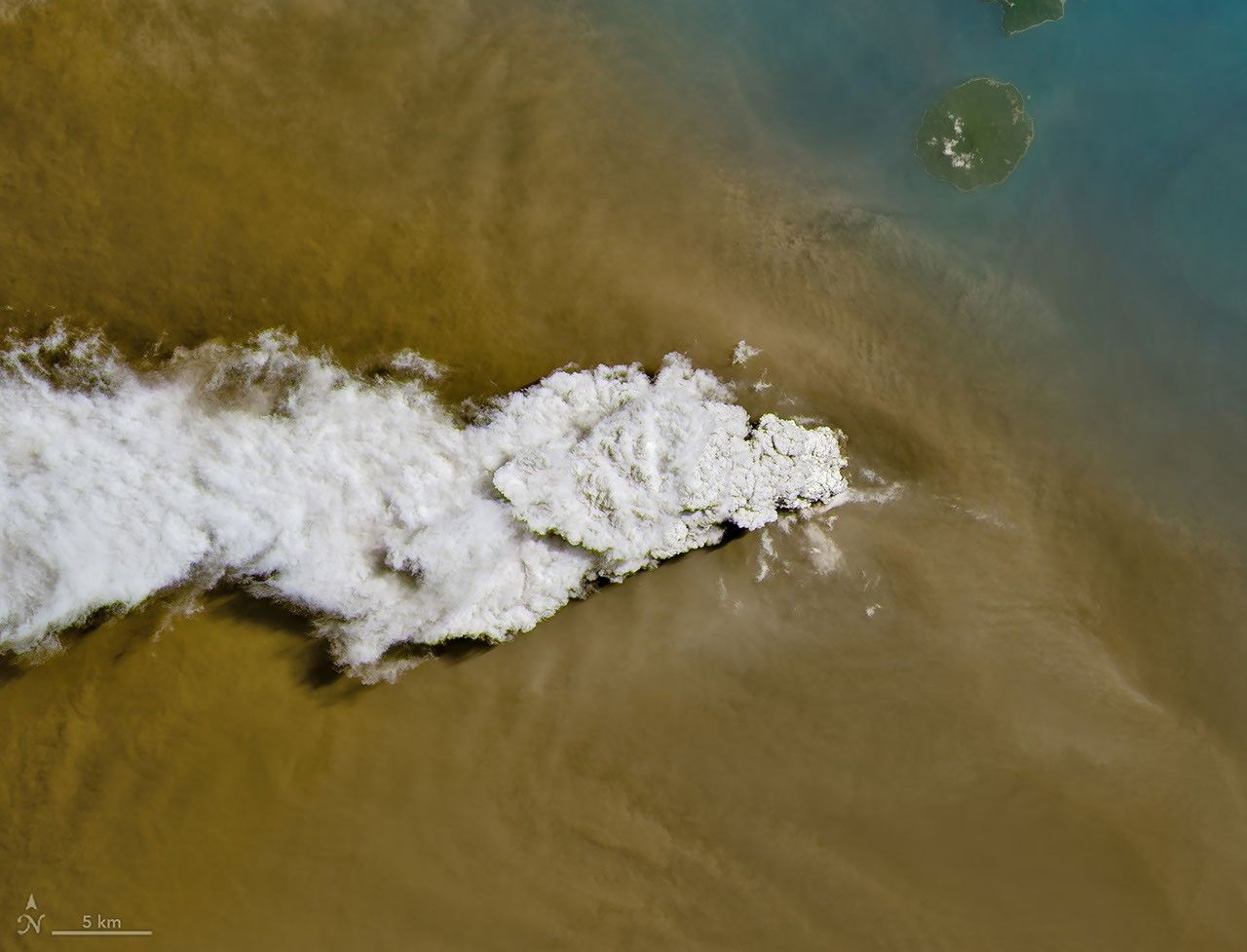
To follow different stages of the event, researchers used three orbital observation systems. On September 5, Landsat 8 recorded a white plume of gas above the brown ash cloud; the VIIRS instrument aboard Suomi NPP showed the material dispersing across a much wider region. Days later, Sentinel imagery made it possible to compare the shoreline and calculate the area above the water. Each instrument answered a different question: what was leaving the crater, how far it spread and how the volcano’s outline had changed.
One formation appears about 760 meters northwest of Anak Krakatau’s coast; the other lies 495 meters to the southeast. The images show features above the water, but fieldwork is still needed to establish whether they are separate, persistent islands, simple accumulations of material or eruptive vents—places from which lava, gases or fragments are being emitted.
The instruments also recorded deflation, a tendency for the ground to contract or subside that is consistent with lower pressure in the volcanic system. That finding helps explain the lower alert level. The stability of the newly formed area will depend on what happens next: waves, erosion and future eruptions can continue to reshape the terrain. The central finding is not simply that Anak Krakatau has ‘grown,’ but that in less than eight years the volcano has rebuilt an above-water surface larger than the one it had before the 2018 collapse.
Key points
- Anak Krakatau is an island volcano between Java and Sumatra; in 2018, the collapse of one of its flanks reduced its area and triggered a tsunami.
- In September 2026, a 25-hour eruptive phase covered 32.8 hectares with new deposits; the total surface above the sea reached 341.5 hectares.
- The deposit area is equivalent to about 46 football pitches; two nearby formations still need to be examined in the field.
Comments
No comments have been published yet.
Sign in with a subscription to comment.